 |
Imnaha
is a small community located in northeast Oregon at the confluence of the Little Sheep Creek and the Imnaha River. It is part of Wallowa County, situated at an elevation of 1,965 feet. The population is approximately 180 (including nearby ranches.) The closest larger city is Joseph, Oregon, about 30 miles west of Imnaha. Oregon Route 350 connects the two communities. Imnaha is definitely an area for nature lovers who like to get away from it all. Tucked into the northeast corner of the state, the whole county is home to only 7,000 residents. Wallowa County is surrounded by incredible natural beauty and boasts Oregon's largest wilderness area, the clearest lake, deepest gorge and greenest of valleys. Highlights include Wallowa Lake and the Hells Canyon Scenic Byway. Wallowa Lake is a crystal-clear glacier lake formed about 9 million years ago. It offers excellent trout fishing, canoeing, camping and a trail head that takes you deep into the Eagle Cap Wilderness, which is Oregon's largest wilderness area. Wallowa County is also filled with many miles of hiking and cycling trails, and opportunities for wildlife viewing and photography, birding, fly fishing on the Snake River, rafting, kayaking, horseback riding, and skiing and snowboarding. Imnaha is also near Hells Canyon Recreation Area, one of the state's most rugged natural areas.

|
Imnaha Vacation Rentals
|

|
|
|
|
|
Imnaha Hotels and Resorts
|
|
|
| | | Hotels & Motels |
| Ponderosa Motel | 102 E Greenwood St | Enterprise, OR | 23.5 mi. | (541) 426-3186 | | Shilo Inn Troy Lodge | | Enterprise, OR | 23.5 mi. | (541) 641-6565 | | Wilderness Inn Motel | 301 W North St | Enterprise, OR | 23.6 mi. | (541) 426-4535 | | Best Western Rama Inn & Suites | 1200 Highland Ave | Enterprise, OR | 24.5 mi. | (541) 426-2000 | | Best Western Salmon Rapids Lodge | 1010 S Main | Riggins, ID | 26.8 mi. | (877) 957-2743 |

|
Imnaha Weather & Climate
|

|
|
|
Mountains that protect the valley from the most severe aspects of weather encircle northeastern Oregon, near Wallowa Lake and the Eagle Cap Wilderness Area. The mountains also prevent moisture from reaching the valley, so it has a fairly dry climate. Most of the precipitation in the area occurs in fall and winter, and varies from just over seven inches in the valley up to 60 inches in the mountains. Summers are warm and pleasant with low humidity. Thunderstorms are possible in spring and summer. Heavy snowfall in the high mountains produces snow packs that remain all year long on the higher peaks. Light snow can be expected in the valley regions from late November to early April. January is usually the coldest month and July is the hottest.
|
| Month |
High Temp |
Low Temp |
Rainfall |
Ocean Temp |
| January |
36°F |
16°F |
1.70 in. |
- |
| February |
43°F |
20°F |
1.47 in. |
- |
| March |
51°F |
25°F |
1.66 in. |
- |
| April |
59°F |
29°F |
1.94 in. |
- |
| May |
67°F |
35°F |
2.25 in. |
- |
| June |
75°F |
40°F |
1.95 in. |
- |
| July |
85°F |
43°F |
1.30 in. |
- |
| August |
86°F |
42°F |
1.15 in. |
- |
| September |
77°F |
35°F |
1.13 in. |
- |
| October |
63°F |
28°F |
1.19 in. |
- |
| November |
45°F |
24°F |
2.16 in. |
- |
| December |
36°F |
17°F |
1.90 in. |
- |

|
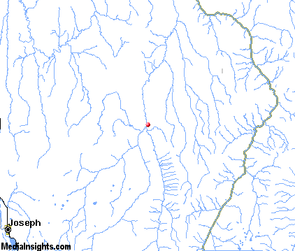
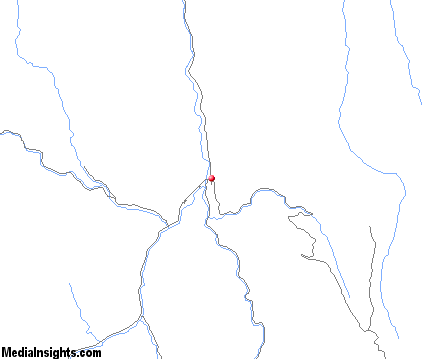
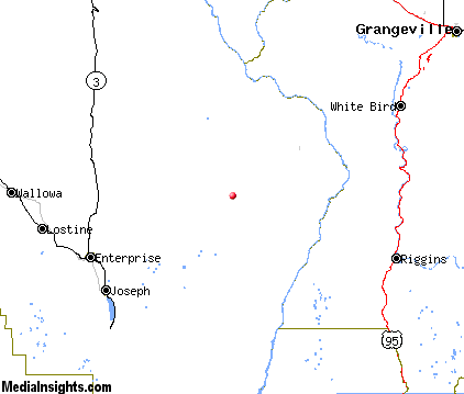
Imnaha Map & Transportation
|

|
|
 |
|
|
| Click each thumbnail image to enlarge. |
 |
|
 |
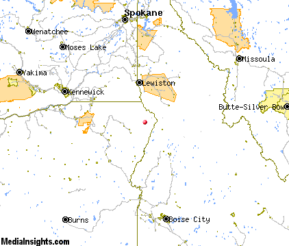 |
The closest airports in the area are the Joseph State airport (4S3) located about 24 miles southwest of Imnaha in Joseph, Oregon, the Idaho County airport (S80) located approximately 43 miles northeast of Imnaha in Grangeville, Idaho, the Lewiston Nez Perce County airport (LWS) located roughly 57 miles north of Imnaha in Lewiston, Idaho, the Mc Call Municipal airport (MYL) located around 58 miles southeast of Imnaha in Mccall, Idaho, the La Grande Union County airport (LGD) located about 59 miles west of Imnaha in La Grande, Oregon, and finally the Baker City Municipal airport (BKE) located approximately 68 miles southwest of Imnaha in Baker City, Oregon.
|

|
Imnaha Attractions
|

|
|
| | | Golf Courses |
| Alpine Meadows Golf Course | Enterprise | OR | 23.3 mi. | |
| | | Ski Areas |
| Anthony Lakes | Island City | OR | 60.6 mi. | | | Spout Springs | Weston | OR | 78.8 mi. | |
| | | State Parks |
| Wallowa Lake State Park | | OR | 27.6 mi. | | | Fields Spring State Park | | WA | 39.3 mi. | |
Notice a problem with the information on this page? Please notify us.
|
Disclaimer: We recommend you conduct your own research regarding all accomodations and attractions found on this website. The distances shown on this website are straight-line distances as the crow flies. The road distance may be considerably longer. You assume all liability for use of any information found on this website. No information is confirmed or warranted in any way. By using our services you agree to the terms and conditions of this disclaimer.
|
| We are the #1 site for your Oregon Vacations presenting Oregon vacation rentals, hotels, weather and map for each city. |
Oregon Vacations .com
©1997-2025 All Rights Reserved.
|
|