 |
Joseph
is a town of approximately 1,050 residents, located in Wallowa County in the northeast corner of the state. The town was originally named Silver Lake and then Lake City, but in 1880, the city formally renamed itself for Nez Perce Chief Joseph. Located in one of the most beautiful natural areas of the state, Joseph is a small town that is big on attractions. It is near the Hells Canyon National Recreation Area and Scenic Byway, Eagle Cap Wilderness and Wallowa Lake State Park. Outdoor activities include fishing, boating, canoeing, hiking, golf, camping, horseback riding, downhill and cross-country skiing. Wallowa Lake is a five-mile long crystal-clear lake formed by a glacier about 9 million years ago. Trout fishing in the lake is superb and a trail head at Wallowa Lake takes you deep into Eagle Cap Wilderness, which is Oregon's largest wilderness area. Eagle Cap is also one of Oregon's premier backpacking areas, home to over 50 incredible high-mountain lakes. The town is home to museums and specialty stores and seven permanent bronze sculptures are on display on Main Street. The town sponsors the annual Chief Joseph Days Rodeo each July and the Bronze, Blues and Brews Festival each August. Other special events include an annual arts festival in June and the Annual Alpenfest in September.

|
Joseph Vacation Rentals
|

|
|
|
|
|
Joseph Hotels and Resorts
|
|
|
| | | Hotels & Motels |
| Ponderosa Motel | 102 E Greenwood St | Enterprise, OR | 5.4 mi. | (541) 426-3186 | | Shilo Inn Troy Lodge | | Enterprise, OR | 5.5 mi. | (541) 641-6565 | | Wilderness Inn Motel | 301 W North St | Enterprise, OR | 5.6 mi. | (541) 426-4535 | | Best Western Rama Inn & Suites | 1200 Highland Ave | Enterprise, OR | 5.9 mi. | (541) 426-2000 |

|
Joseph Weather & Climate
|

|
|
|
Mountains that protect the valley from the most severe aspects of weather encircle northeastern Oregon, near Wallowa Lake and the Eagle Cap Wilderness Area. The mountains also prevent moisture from reaching the valley, so it has a fairly dry climate. Most of the precipitation in the area occurs in fall and winter, and varies from just over seven inches in the valley up to 60 inches in the mountains. Summers are warm and pleasant with low humidity. Thunderstorms are possible in spring and summer. Heavy snowfall in the high mountains produces snow packs that remain all year long on the higher peaks. Light snow can be expected in the valley regions from late November to early April. January is usually the coldest month and July is the hottest.
|
| Month |
High Temp |
Low Temp |
Rainfall |
Ocean Temp |
| January |
35°F |
18°F |
1.84 in. |
- |
| February |
42°F |
22°F |
1.44 in. |
- |
| March |
51°F |
27°F |
1.30 in. |
- |
| April |
60°F |
31°F |
1.39 in. |
- |
| May |
68°F |
37°F |
1.76 in. |
- |
| June |
76°F |
42°F |
1.44 in. |
- |
| July |
85°F |
46°F |
0.94 in. |
- |
| August |
85°F |
44°F |
0.89 in. |
- |
| September |
76°F |
37°F |
1.09 in. |
- |
| October |
63°F |
30°F |
1.33 in. |
- |
| November |
45°F |
26°F |
2.07 in. |
- |
| December |
35°F |
19°F |
1.91 in. |
- |

|
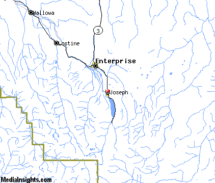
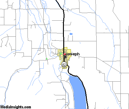
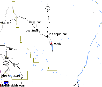
Joseph Map & Transportation
|

|
|
 |
|
|
| Click each thumbnail image to enlarge. |
 |
|
 |
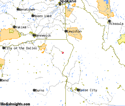 |
The closest airports in the area are the La Grande Union County airport (LGD) located about 38 miles west of Joseph in La Grande, Oregon, the Mc Call Municipal airport (MYL) located approximately 63 miles southeast of Joseph in Mccall, Idaho, the Lewiston Nez Perce County airport (LWS) located roughly 71 miles north of Joseph in Lewiston, Idaho, and finally the Walla Walla Regional airport (ALW) located around 72 miles northwest of Joseph in Walla Walla, Washington.
|

|
Joseph Attractions
|

|
|
| | | Golf Courses |
| Alpine Meadows Golf Course | Enterprise | OR | 5.0 mi. | |
| | | Ski Areas |
| Anthony Lakes | Island City | OR | 39.6 mi. | | | Spout Springs | Weston | OR | 65.9 mi. | |
| | | State Parks |
| Wallowa Lake State Park | | OR | 6.6 mi. | | | Catherine Creek State Park | | OR | 28.2 mi. | | | Wallowa Lake Highway Forest State Park | | OR | 28.6 mi. | | | Minam State Park | | OR | 37.5 mi. | |
Notice a problem with the information on this page? Please notify us.
|
Disclaimer: We recommend you conduct your own research regarding all accomodations and attractions found on this website. The distances shown on this website are straight-line distances as the crow flies. The road distance may be considerably longer. You assume all liability for use of any information found on this website. No information is confirmed or warranted in any way. By using our services you agree to the terms and conditions of this disclaimer.
|
| We are the #1 site for your Oregon Vacations presenting Oregon vacation rentals, hotels, weather and map for each city. |
Oregon Vacations .com
©1997-2025 All Rights Reserved.
|
|