 |
Grants-Pass
is the second largest city in southern Oregon and is located along the banks of the Rogue River, which is one of the country's original "wild and scenic" rivers, well known as one of the best white water rafting rivers in the Northwest. The city is a popular departure point for many rafters, and Hellgate Canyon, northwest of Grants Pass, marks the Rogue River's entrance to the Coast Ranges. The city of Grants Pass is nestled along the northern Siskiyou Mountains on Interstate 5, just 55 miles north of the California State line between the towns of Medford and Roseburg. With its' convenient location, Grants Pass is ideal for exploring the Oregon Coast, Giant Redwoods, Oregon Caves National Monument and Crater Lake National Park. The town's motto is "Where the Rogue River Runs," and it's said to be a "natural amusement park for outdoor enthusiasts." Whether rafting, fishing or hiking, the area is one of the most scenic and tourist friendly places on the West Coast. The town's historic downtown is filled to the brim with art galleries, antique shops, specialty shops and restaurants. Designated as a National Historic District, Grants Pass is home to "The Grower's Market," which is one of the largest open-air markets in the state, featuring fresh produce, fruits, nuts, diary products and flowers. Grants Pass also hosts an annual Boatnik Festival, usually held in the month of May.

|
Grants Pass Vacation Rentals
|

|
|
|
|
|
Grants Pass Hotels and Resorts
|
|
|
| | | Hotels & Motels |
| Best Western Inn At The Rogue | 8959 Rogue Riv Hwy | Grants Pass, OR | | (541) 582-2200 | | Best Western Inn | 111 Ne Agness Ave | Grants Pass, OR | | (541) 476-1117 | | Comfort Inn | 1889 Ne 6TH St | Grants Pass, OR | | (541) 479-8301 | | Grants Pass Shilo Inn | 1880 NW 6TH St | Grants Pass, OR | | (541) 479-8391 | | Grants Pass Travelodge | 1950 NW Vine | Grants Pass, OR | | (541) 479-6611 | | Holiday Inn Express Grants Pass | 105 Ne Agness Ave | Grants Pass, OR | | (541) 471-6144 | | La Quinta Inn & Suites | 243 Ne Morgan Ln | Grants Pass, OR | | (541) 472-1808 | | Motel 6 #253 | 1800 North East Seventh | Grants Pass, OR | | (541) 474-1331 | | Rodeway Inn | 1253 NE 6th St | Grants Pass, OR | | (541) 479-2952 | | Super 8 Motel | 1949 Ne 7TH St | Grants Pass, OR | | (541) 474-0888 | | Sweet Breeze Inn | 1627 NE 6th St | Grants Pass, OR | | (541) 471-4434 | | Morrison's Rogue River Lodge | 8500 Galice Rd | Merlin, OR | 10.4 mi. | (541) 476-3825 | | Our Shepherd's Inn | 159 Bloom Rd | Wolf Creek, OR | 17.2 mi. | (541) 866-2501 | | The Stage Lodge Motel | 830 N 5TH St | Jadksonville, OR | 20.5 mi. | (541) 899-3953 | | Holiday Inn Express Hotel & Suites | 285 Penninger St | Central Point, OR | 22.2 mi. | (541) 423-1010 | | Courtyard By Marriott Medford Airport | 600 Airport Rd | Medford, OR | 23.1 mi. | (541) 772-5656 | | Motel 6 | 2400 Biddle Rd | Medford, OR | 23.8 mi. | (541) 779-0550 | | Comfort Inn North | 2280 Biddle Rd | Medford, OR | 23.9 mi. | (541) 772-9500 | | Ramada & Convention Center | 2250 Biddle Rd | Medford, OR | 23.9 mi. | (541) 779-3141 | | Rogue Regency Inn | 2300 Biddle Rd | Medford, OR | 23.9 mi. | (541) 770-1234 | | Windmill Inn Of Medford | 1950 Biddle Rd | Medford, OR | 23.9 mi. | (800) 547-4747 | | Hampton Inn | 1122 Morrow Rd | Medford, OR | 24.1 mi. | (541) 779-0660 | | Shilo Inn Medford | 2111 Biddle Rd | Medford, OR | 24.1 mi. | (541) 641-6565 | | Best Western Pony Soldier Inn Medford | 2340 Crater LK Hwy | Medford, OR | 24.4 mi. | (541) 779-2011 | | Candlewood Suites | 3548 Heathrow Way | Medford, OR | 24.4 mi. | (541) 772-2800 | | Red Lion Hotel Medford | 200 N Riverside | Medford, OR | 24.4 mi. | (541) 779-5811 | | Red Carpet Inn | 525 S Riverside | Medford, OR | 24.9 mi. | (541) 772-6133 | | Comfort Inn South | 60 E Stewart Ave | Medford, OR | 25.5 mi. | (541) 772-8000 | | Days Inn Of Medford Or | 850 Alba Dr | Medford, OR | 25.5 mi. | (541) 779-6730 | | Best Western Horizon Inn | 1154 Barnett Rd | Medford, OR | 25.7 mi. | (541) 779-5085 | | Motel 6 #89 | 950 Alba Dr | Medford, OR | 25.7 mi. | (541) 773-4290 | | Travelodge Of Medford | 954 Alba Dr | Medford, OR | 25.7 mi. | (541) 773-1579 | | Fairfield Inn And Suites By Marriott | 1777 Larue Dr | Central Point, OR | 26.1 mi. | (541) 665-4141 | | Holiday Inn Express | 1501 S Pacific Hwy | Medford, OR | 26.9 mi. | (541) 732-1400 | | Super 8 | 300 Pear Tree Ln | Phoenix, OR | 28.5 mi. | (541) 535-4445 | | The Edgewater Inn | 7800 Rogue River Dr | Shady Cove, OR | 28.9 mi. | (541) 878-3171 |
| | | Bed & Breakfast |
| Ahlf House Bed & Breakfast | 762 NW 6TH St | Grants Pass, OR | | (541) 474-1374 |

|
Grants Pass Weather & Climate
|

|
|
|
The Rogue River Valley area is at an elevation of about 1,000 feet above sea level in the heart of a region where three mountain ranges meet. These three ranges- The Cascades, the Siskiyous and the Coast Range- meet in the Rogue Valley and create a pleasant climate. The area generally sees warm, dry summers with cool evenings, and moderate winters. The hottest month is July and the coldest month is January. December is often the wettest month and average annual precipitation is less than 30 inches. Grants Pass is located in the "sun belt" of southern Oregon. This area boasts a gentle wind velocity, averaging only 3.2 mph. Plan on warm, sunny days with cool, dry evenings from mid-May through mid-September.
|
| Month |
High Temp |
Low Temp |
Rainfall |
Ocean Temp |
| January |
47°F |
31°F |
4.96 in. |
- |
| February |
54°F |
32°F |
4.36 in. |
- |
| March |
59°F |
34°F |
3.66 in. |
- |
| April |
65°F |
35°F |
2.02 in. |
- |
| May |
73°F |
40°F |
1.21 in. |
- |
| June |
80°F |
45°F |
0.53 in. |
- |
| July |
88°F |
49°F |
0.37 in. |
- |
| August |
89°F |
48°F |
0.45 in. |
- |
| September |
82°F |
43°F |
0.87 in. |
- |
| October |
70°F |
37°F |
2.07 in. |
- |
| November |
53°F |
34°F |
5.12 in. |
- |
| December |
45°F |
31°F |
5.40 in. |
- |

|
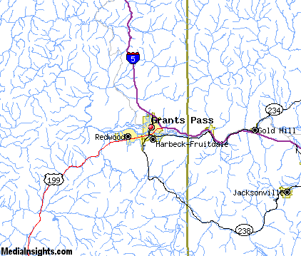
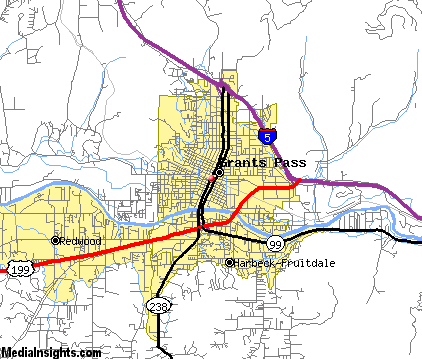
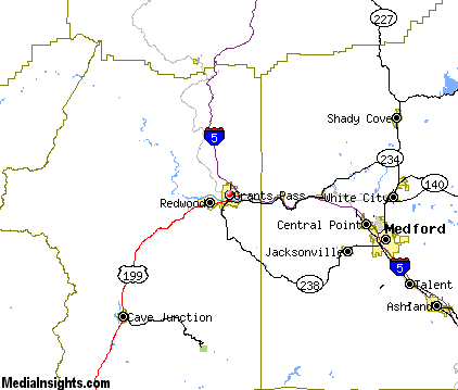
Grants Pass Map & Transportation
|

|
|
 |
|
|
| Click each thumbnail image to enlarge. |
 |
|
 |
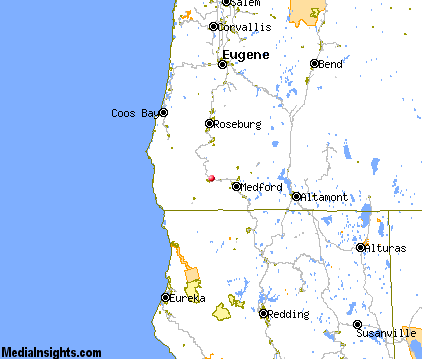 |
The closest airports in the area are the Rogue Valley International Medford airport (MFR) located about 23 miles east of Grants Pass in Medford, Oregon, the Illinois Valley airport (3S4) located approximately 29 miles southwest of Grants Pass in Cave Junction, Oregon, the Siskiyou County airport (SIY) located roughly 63 miles southeast of Grants Pass in Montague, California, Jack Mc Namara Field (CEC) located around 65 miles southwest of Grants Pass in Crescent City, California, and finally the Cape Blanco State airport (5S6) located about 67 miles northwest of Grants Pass in Denmark, Oregon.
|

|
Grants Pass Attractions
|

|
|
| | | Golf Courses |
| Applegate Golf | Grants Pass | OR | | | | Colonial Valley Golf Course | Grants Pass | OR | | | | Dutcher Creek Golf Course | Grants Pass | OR | | | | Grants Pass Golf Club | Grants Pass | OR | | | | Red Mountain Golf Course | Grants Pass | OR | | | | Bear Creek Golf Course & Range | Medford | OR | 24.8 mi. | | | Cedar Links Golf Club | Medford | OR | 24.8 mi. | | | Quail Point Golf Course | Medford | OR | 24.8 mi. | | | Stewart Meadows | Medford | OR | 24.8 mi. | | | Illinois Valley Golf Club | Cave Junction | OR | 25.1 mi. | | | Eagle Point Golf Course | Eagle Point | OR | 27.0 mi. | | | Stone Ridge Golf Club | Eagle Point | OR | 27.0 mi. | |
| | | Ski Areas |
| Mount Ashland | Ashland | OR | 35.9 mi. | | | Willamette Pass | Eugene | OR | 112.1 mi. | |
| | | State Parks |
| Valley of the Rogue State Park | | OR | 9.8 mi. | | | Ben Hur Lampman State Park | | OR | 14.2 mi. | | | Wolf Creek Inn State Park | | OR | 17.6 mi. | | | Stage Coach Forest State Park | | OR | 20.2 mi. | | | TouVelle State Park | | OR | 22.8 mi. | | | Illinois River Forks State Park | | OR | 25.9 mi. | | | Rough and Ready State Park | | OR | 30.1 mi. | | | Canyon Creek Forest State Park | | OR | 31.5 mi. | | | Casey State Park | | OR | 35.9 mi. | |
| | | Zoos and Aquariums |
| Wildlife Safari | Winston | OR | 47.4 mi. | |
Notice a problem with the information on this page? Please notify us.
|
Disclaimer: We recommend you conduct your own research regarding all accomodations and attractions found on this website. The distances shown on this website are straight-line distances as the crow flies. The road distance may be considerably longer. You assume all liability for use of any information found on this website. No information is confirmed or warranted in any way. By using our services you agree to the terms and conditions of this disclaimer.
|
| We are the #1 site for your Oregon Vacations presenting Oregon vacation rentals, hotels, weather and map for each city. |
Oregon Vacations .com
©1997-2025 All Rights Reserved.
|
|