 |
Jacksonville
is a charming small town nestled in southern Oregons rolling hills, a few miles west of Medford. The entire town of Jacksonville is a National Historic Landmark with stories of Native Americans, Chinese immigrants and gold miners woven into its rich historical background. The Jacksonville Museum includes tours with photographic story boards and artifacts, and a Childrens Museum offers interactive play in a real general store, old school house and a miniature railroad. During the summer months, a town trolley takes visitors on a tour of over 100 historic buildings dating to the mid 1800s. The quaint brick and wood buildings now house restaurants, spas, unique shops and lodging. Jacksonville was home to the first Chinatown in Oregon, founded by San Francisco immigrants. In March 2004, road workers discovered artifacts of the era and construction was halted while archaeologists worked to uncover Chinese bowls, tea cups, coins and other items. The town of Jacksonville is also known for the Britt Festival, a seasonal event that takes place at an open-air amphitheater that was chosen because of the fantastic acoustic qualities of the surrounding hills. This popular concert series attracts hundreds for its national pop, country, alternative and contemporary music acts. Jacksonville is also situated at the entrance to the Applegate Wine Country and is just a days drive to the scenic Rogue River Recreational Area.

|
Jacksonville Vacation Rentals
|

|
|
|
|
|
Jacksonville Hotels and Resorts
|
|
|
| | | Hotels & Motels |
| The Stage Lodge Motel | 830 N 5TH St | Jadksonville, OR | | (541) 899-3953 | | Best Western Pony Soldier Inn Medford | 2340 Crater LK Hwy | Medford, OR | 4.8 mi. | (541) 779-2011 | | Candlewood Suites | 3548 Heathrow Way | Medford, OR | 4.8 mi. | (541) 772-2800 | | Red Lion Hotel Medford | 200 N Riverside | Medford, OR | 4.9 mi. | (541) 779-5811 | | Red Carpet Inn | 525 S Riverside | Medford, OR | 5.1 mi. | (541) 772-6133 | | Shilo Inn Medford | 2111 Biddle Rd | Medford, OR | 5.2 mi. | (541) 641-6565 | | Windmill Inn Of Medford | 1950 Biddle Rd | Medford, OR | 5.2 mi. | (800) 547-4747 | | Comfort Inn North | 2280 Biddle Rd | Medford, OR | 5.3 mi. | (541) 772-9500 | | Hampton Inn | 1122 Morrow Rd | Medford, OR | 5.3 mi. | (541) 779-0660 | | Motel 6 | 2400 Biddle Rd | Medford, OR | 5.3 mi. | (541) 779-0550 | | Ramada & Convention Center | 2250 Biddle Rd | Medford, OR | 5.3 mi. | (541) 779-3141 | | Rogue Regency Inn | 2300 Biddle Rd | Medford, OR | 5.3 mi. | (541) 770-1234 | | Holiday Inn Express Hotel & Suites | 285 Penninger St | Central Point, OR | 5.5 mi. | (541) 423-1010 | | Comfort Inn South | 60 E Stewart Ave | Medford, OR | 5.5 mi. | (541) 772-8000 | | Days Inn Of Medford Or | 850 Alba Dr | Medford, OR | 5.6 mi. | (541) 779-6730 | | Courtyard By Marriott Medford Airport | 600 Airport Rd | Medford, OR | 5.7 mi. | (541) 772-5656 | | Best Western Horizon Inn | 1154 Barnett Rd | Medford, OR | 5.8 mi. | (541) 779-5085 | | Motel 6 #89 | 950 Alba Dr | Medford, OR | 5.8 mi. | (541) 773-4290 | | Travelodge Of Medford | 954 Alba Dr | Medford, OR | 5.8 mi. | (541) 773-1579 | | Holiday Inn Express | 1501 S Pacific Hwy | Medford, OR | 6.6 mi. | (541) 732-1400 | | Fairfield Inn And Suites By Marriott | 1777 Larue Dr | Central Point, OR | 7.2 mi. | (541) 665-4141 | | Super 8 | 300 Pear Tree Ln | Phoenix, OR | 8.2 mi. | (541) 535-4445 | | Econo Lodge | 50 Lowe Rd | Ashland, OR | 13.0 mi. | (541) 482-4700 | | La Quinta Inn & Suites | 434 Valley View Rd | Ashland, OR | 13.0 mi. | (541) 482-6932 | | Plaza Inn & Suites At Ashland Creek | 98 Central Ave | Ashland, OR | 15.0 mi. | (541) 488-8900 | | Ashland Springs Hotel | 212 East Main St | Ashland, OR | 15.3 mi. | (541) 488-1700 | | Green Springs Inn | 11470 Hwy 66 | Ashland, OR | 15.5 mi. | (541) 482-0614 | | Super 8 Motel Ashland | 2350 Ashland St | Ashland, OR | 17.6 mi. | (541) 482-8887 | | Holiday Inn Express & Suites | 565 Clover Ln | Ashland, OR | 17.9 mi. | (541) 201-0202 | | Best Western Inn | 111 Ne Agness Ave | Grants Pass, OR | 19.0 mi. | (541) 476-1117 | | Holiday Inn Express Grants Pass | 105 Ne Agness Ave | Grants Pass, OR | 19.0 mi. | (541) 471-6144 | | Best Western Inn At The Rogue | 8959 Rogue Riv Hwy | Grants Pass, OR | 20.4 mi. | (541) 582-2200 | | Motel 6 #253 | 1800 North East Seventh | Grants Pass, OR | 20.4 mi. | (541) 474-1331 | | Rodeway Inn | 1253 NE 6th St | Grants Pass, OR | 20.5 mi. | (541) 479-2952 | | La Quinta Inn & Suites | 243 Ne Morgan Ln | Grants Pass, OR | 20.7 mi. | (541) 472-1808 | | Super 8 Motel | 1949 Ne 7TH St | Grants Pass, OR | 20.8 mi. | (541) 474-0888 | | Sweet Breeze Inn | 1627 NE 6th St | Grants Pass, OR | 20.8 mi. | (541) 471-4434 | | Comfort Inn | 1889 Ne 6TH St | Grants Pass, OR | 20.9 mi. | (541) 479-8301 | | Grants Pass Shilo Inn | 1880 NW 6TH St | Grants Pass, OR | 20.9 mi. | (541) 479-8391 | | Grants Pass Travelodge | 1950 NW Vine | Grants Pass, OR | 20.9 mi. | (541) 479-6611 |
| | | Bed & Breakfast |
| Ahlf House Bed & Breakfast | 762 NW 6TH St | Grants Pass, OR | 20.4 mi. | (541) 474-1374 |

|
Jacksonville Weather & Climate
|

|
|
|
The Rogue River Valley area is at an elevation of about 1,000 feet above sea level in the heart of a region where three mountain ranges meet. These three ranges- The Cascades, the Siskiyous and the Coast Range- meet in the Rogue Valley and create a pleasant climate. The area generally sees warm, dry summers with cool evenings, and moderate winters. The hottest month is July and the coldest month is January. December is often the wettest month and average annual precipitation is less than 30 inches. Grants Pass is located in the "sun belt" of southern Oregon. This area boasts a gentle wind velocity, averaging only 3.2 mph. Plan on warm, sunny days with cool, dry evenings from mid-May through mid-September.
|
| Month |
High Temp |
Low Temp |
Rainfall |
Ocean Temp |
| January |
46°F |
30°F |
2.77 in. |
- |
| February |
53°F |
32°F |
2.32 in. |
- |
| March |
57°F |
34°F |
2.26 in. |
- |
| April |
64°F |
37°F |
1.61 in. |
- |
| May |
71°F |
42°F |
1.41 in. |
- |
| June |
79°F |
47°F |
0.77 in. |
- |
| July |
87°F |
51°F |
0.50 in. |
- |
| August |
87°F |
50°F |
0.57 in. |
- |
| September |
79°F |
44°F |
0.95 in. |
- |
| October |
67°F |
37°F |
1.51 in. |
- |
| November |
51°F |
34°F |
3.20 in. |
- |
| December |
45°F |
30°F |
3.27 in. |
- |

|
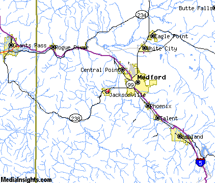
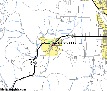
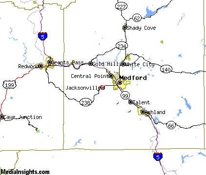
Jacksonville Map & Transportation
|

|
|
 |
|
|
| Click each thumbnail image to enlarge. |
 |
|
 |
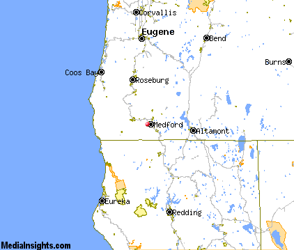 |
The closest airports in the area are the Rogue Valley International Medford airport (MFR) located about 6 miles northeast of Jacksonville in Medford, Oregon, the Illinois Valley airport (3S4) located approximately 39 miles west of Jacksonville in Cave Junction, Oregon, the Siskiyou County airport (SIY) located roughly 44 miles southeast of Jacksonville in Montague, California, the Klamath Falls airport (LMT) located around 63 miles east of Jacksonville in Klamath Falls, Oregon, the Weed airport (O46) located about 63 miles south of Jacksonville in Weed, California, and finally Jack Mc Namara Field (CEC) located approximately 74 miles west of Jacksonville in Crescent City, California.
|

|
Jacksonville Attractions
|

|
|
| | | Golf Courses |
| Bear Creek Golf Course & Range | Medford | OR | 4.9 mi. | | | Cedar Links Golf Club | Medford | OR | 4.9 mi. | | | Quail Point Golf Course | Medford | OR | 4.9 mi. | | | Stewart Meadows | Medford | OR | 4.9 mi. | | | Eagle Point Golf Course | Eagle Point | OR | 13.7 mi. | | | Stone Ridge Golf Club | Eagle Point | OR | 13.7 mi. | | | Applegate Golf | Grants Pass | OR | 19.8 mi. | | | Colonial Valley Golf Course | Grants Pass | OR | 19.8 mi. | | | Dutcher Creek Golf Course | Grants Pass | OR | 19.8 mi. | | | Grants Pass Golf Club | Grants Pass | OR | 19.8 mi. | | | Red Mountain Golf Course | Grants Pass | OR | 19.8 mi. | |
| | | Ski Areas |
| Mount Ashland | Ashland | OR | 15.5 mi. | |
| | | State Parks |
| Ben Hur Lampman State Park | | OR | 8.5 mi. | | | TouVelle State Park | | OR | 9.8 mi. | | | Valley of the Rogue State Park | | OR | 11.1 mi. | | | Casey State Park | | OR | 27.8 mi. | | | Tub Springs State Park | | OR | 30.8 mi. | | | Joseph H Stewart State Park | | OR | 31.1 mi. | | | Wolf Creek Inn State Park | | OR | 33.8 mi. | | | Stage Coach Forest State Park | | OR | 35.1 mi. | | | Illinois River Forks State Park | | OR | 36.8 mi. | | | Prospect State Park | | OR | 38.1 mi. | | | Rough and Ready State Park | | OR | 39.7 mi. | |
| | | Zoos and Aquariums |
| Wildlife Safari | Winston | OR | 60.3 mi. | |
Notice a problem with the information on this page? Please notify us.
|
Disclaimer: We recommend you conduct your own research regarding all accomodations and attractions found on this website. The distances shown on this website are straight-line distances as the crow flies. The road distance may be considerably longer. You assume all liability for use of any information found on this website. No information is confirmed or warranted in any way. By using our services you agree to the terms and conditions of this disclaimer.
|
| We are the #1 site for your Oregon Vacations presenting Oregon vacation rentals, hotels, weather and map for each city. |
Oregon Vacations .com
©1997-2025 All Rights Reserved.
|
|